Feedback on the proposed changes has now been reviewed, and an external independent analysis has been undertaken considering community feedback, road network and safety factors.
The changes listed below will now be formally submitted to the Department of Transport and Planning for approval. Pending approval, updated signage will then be installed.
Atkins Road, Winchelsea - East of Mathisons Road
- Current: 100kph default limit
- Retain existing: 100kph default speed limit east of Mathisons Road.
The primary considerations which influenced this recommendation are as follows:
- Wider carriageway width and shoulders
- Blackspot project funded to provide additional barrier to protect roadside hazards
- Straight Road Alignment
- Road Safety Treatments such as rumble edge lines, shoulders and barrier reduce crash risk
- Relatively low traffic volumes, straight alignment and few vulnerable road users
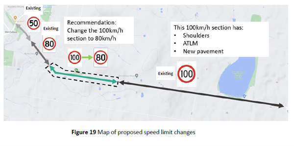
Atkins Road, Winchelsea - West of Mathisons Road (where road narrows)
- Current: 100kph default limit
- New limit to be adopted: reduce speed limit to 80kph west of Mathisons Road
The primary considerations which influenced this recommendation are as follows:
- Curved geometry around Orchards Road
- Lack of sealed shoulder and edge line treatments through this section
- Roadside hazards present close to the road including utility poles and vegetation
- Poor pavement condition in some sections
For further details on the analysis and recommendation please refer to link to the analysis report below.
Atkins Road had four crashes over the past ten years of which one resulted in death.
See stats across the network using interactive crash maps
Buckley Road South, Atkins Road to Cape Otway Road
- Current: 100kph default limit
- Retain existing: 100kph default speed limit
The primary considerations which influenced this recommendation are as follows:
- Wider carriageway width and shoulders
- Limited driveways/ access points along this route
- Straight Road Alignment
- Road Safety Treatments such as rumble edge lines and shoulder reduce crash risk
- No recent crashes on this route
Cape Otway Road, Moriac township
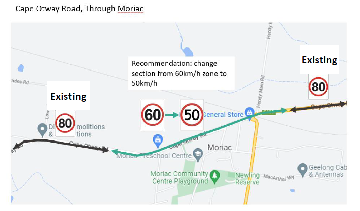
- Current: 60kph signed speed limit
- New limit to be adopted: 50kph signed speed limit
The primary considerations which influenced this recommendation are as follows:
- Vlimit assessment recommends 50kph speed limit as standard treatment
- Pedestrian activity expected around the town centre, with the general store and public toilets on either side
- On-road bicycle lanes with undefined roadside edges
- Level crossing at town centre
- Driveways along road with residential properties adjacent
- School children present with Moriac Primary School in the vicinity
Thirty eight injury crashes occurred on Cape Otway Road between 2010 and 2020. Four people lost their lives in these collisions and twenty resulted in serious injuries.
See stats across the network using interactive crash maps
Cape Otway Road, Taylors Road to Shire Boundary
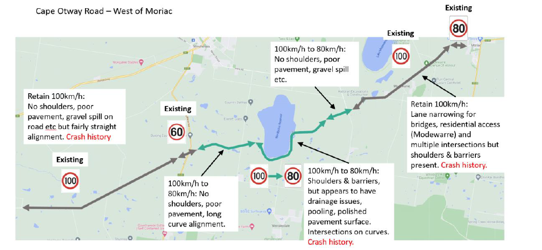
Cape Otway Road, Between Buckley Road South and west of Taylors Road
- Current: 100kph default limit
- Retain existing: default speed limit of 100kph east of Buckley Road South to west of Taylors Road
The primary considerations which influenced this recommendation are as follows:
- Wider carriageway width and shoulders through this section
- Relatively Straight Road Alignment
- Road Safety Treatments such as rumble edge lines and shoulder reduce crash risk
- Reduction in crash rate observable since road safety upgrade works undertaken between 2017 and 2022. Will need to continue to monitor as traffic grows.
Cape Otway Road, Between Buckley Road South and Winchelsea Deans Marsh Road (where road narrows and around reservoir)
- Current: 100kph default limit
- New limit to be adopted: reduce speed limit to 80kph between Buckley Road South and Winchelsea Deans Marsh Road (where road narrows and around reservoir)
The primary considerations which influenced this recommendation are as follows:
- Sharp curves along the route particularly around reservoir
- Narrow carriageway width and no shoulders through a significant portion of this segment
- Significant crash history, with 5 crashes occurring in five years (2 leading to loss of life, 2 serious injuries and 1 other injury)
- Drainage issues leading to pooling and polished pavement surfaces (section parallel to the Wurdiboluc Reservoir)
- Road side hazards close to edge of road with little protection (only small sections have barrier treatments)
- Gravel spill onto the carriageway from unsealed driveways.
- Several priority-controlled intersections along the route, which require motorists to slow from 100kph to safely navigate the intersection
- Presence of vulnerable road users based on local school bus activities
Cape Otway Road, West of Winchlesea-Deans Marsh Road to Salk Creek Lane
- Current: 100kph default limit
- Retain existing: default speed limit of 100kph west of Winchelsea-Deans Marsh Road to Salk Creek Lane
The primary considerations which influenced this recommendation are as follows:
- Limited driveways/ access points along this route
- Relatively Straight Road Alignment
- Lower traffic volumes on this portion of the route leading to reduced cross traffic crash risk
- Lower ten year crash rate along this portion of the route than adjacent segment