The Ridgeline Trail

Update February 2026
We've been busy progressing permits, approvals and detailed design of the Ridgeline Trail.
The permits that we have been working on include:
Tree Impact Assessment
This permit ensures the pathway can be delivered safely, legally and sustainably while protecting tree health and managing risk throughout construction and after the trail is complete.
Three site visits have mapped all 163 trees along the pathway from Duffields Road to Bellbrae Reserve and at the bus stop.
The natural root zone and structural root zone (SRZ) has been calculated for each tree.
This information has been given to the path designer so the path alignment can avoid the SRZ.
Ecological Assessment and Planning Permit
This permit gives decision-makers confidence that vegetation removal is justified, lawful and environmentally responsible.
One site visit undertaken and all ecological (flora, fauna and habitat) characteristics of the area were documented.
The detailed design and tree impact assessment will be issued to the Ecologist, so the ecological assessment can be finalised with the extent of vegetation removal, habitat disturbance and indirect impacts (noise, construction activity).
Cultural Heritage Management Plan
This permit ensures the project is carried out without harming Aboriginal cultural heritage, and any heritage values are identified, protected and properly managed in accordance with legislation.
Desktop assessment has been conducted by Heritage Consultant.
Inception meeting to be held in late February and includes:
- Discussion of the activity including any design plans and proposed impacts.
- Detailed discussion of the activity area including size, salient features, geology/geomorphology and land use history.
- Details of the geographic region.
Fieldwork will be conducted by Wadawurrung Cultural Heritage Fieldwork Officers.
The CHMP will be produced after the fieldwork has been conducted, and will include methodologies and conditions required to avoid or minimise impact to Cultural Heritage (Aboriginal Heritage Act 2006).
Heritage Permit
A heritage permit may be needed for works along the old Great Ocean Road that impact heritage values.
A heritage exemption may be applicable if Heritage Victoria deem the project is unlikely to disturb or damage heritage values.
Road Safety Audit
This audit is undertaken to identify and mitigate safety risks for all users on shared pathways.
The focus of the audit was on interactions between pedestrians, cyclists and vehicles at crossing points.
The audit reviewed the shared path layout, alignment, gradients, sight distances, surface treatments, signage, lighting and interfaces with road and property access points to reduce the likelihood and severity of crashes or conflict points.
Next steps
We will be undertaking works from the road safety audit to install timber bollards, in red in the picture below, to replace the bunting installed during pathway works at the entrance of Christian College Geelong in October 2025. Removeable bollards will be installed at the location marked in blue.
These works will be undertaken before Easter.
The timber bollards to be installed will look like this.
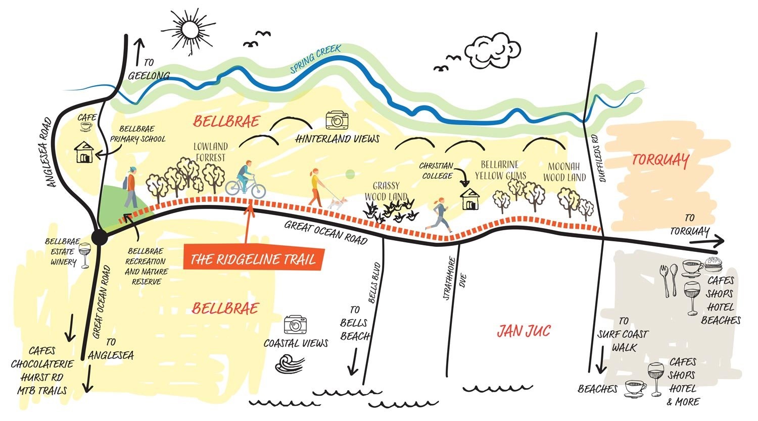
We're preparing for works that align with the Ridgeline Trail Community Vision(PDF, 69MB) which aims to transform a service road into a scenic trail that runs along the Spring Creek Valley ridgeline.
The 3.7km Ridgeline Trail connects Bellbrae, Jan Juc and Torquay, and the upgrade and extension of the current pathway will create a safer journey for children, families and the community.
We're leading two planned pathway projects that align with the community vision:
- An asphalt upgrade of the 2.6km Old Great Ocean Road – between Bellbrae Reserve and Christian College – from a service road to a regional shared trail.
- Construction of a new 1.1km pathway extension from Christian College to Duffields Road. This section is currently a dirt track.
Image: Ferne Millen
What is The Ridgeline Trail?
The Ridgeline Trail is a community trail that connects us to nature, to each other, to Country and culture. It is being brought to life by the local community. School families, local environmental and community groups as well as local businesses are working collaboratively with Council, state government, and utility providers to build the trail.
The Ridgeline Trail is a window into Spring Creek Valley with views across the hinterland to the coast. Situated alongside this beautiful part of Torquay, it's an important nature corridor, which is home to a diversity of fauna and flora species including the rare and endemic Bellarine Yellow Gum.
The Ridgeline Trail and more broadly, Spring Creek Valley is a significant area to the Wadawurrung Traditional Owners. Wadawurrung Traditional Owners believe it’s our shared responsibility to care for Country and to work together to make Wadawurrung Country strong.
Empowering community
We helped community champions capture the Ridgeline Trail Community Vision through our Community Project Development Program, which empowers locals to develop and deliver projects to make their community an even better place to live.
Learn more about The Ridgeline Trail?
Visit the community The Ridgeline Trail website.
Location
Great Ocean Road, Jan Juc View Map
-38.3380152,144.2978752
Great Ocean Road ,
Jan Juc
Great Ocean Road ,
Jan Juc
The Ridgeline Trail
Photo Gallery